Gabhar, now my favourite Munro, almost by definition. 1121 metres, 32th highest in Scotland, but highest in the eastern counties outside the Cairngorms, it commands a huge stretch of land, limited only by the Dee in the north and Loch Ericht in the West. Commands it, but normally ycan't see it, like the famous blind general that actually never existed. Gabhar, on the other hand, exists. Wait, this doesn't make any sense.
The standard route to Gabhar leads over the other two Munros of Beinn a'Ghlo, and it is a nightmare to find. Basically, you come from the mountain, a huge drop to the left, and you have to find the point of the drop that leads to a narrow bridge over to Gabhar on the other side. You grope blindly and fail. And fail again. And fail again. You seek shelter from the storm behind a tiny rock. You crouch and cry. And try again. And fail. And then you see the tiny cairn right where you need to climb down into the clouds. How do people do this? I mean, do they ALL have GPS? Do they all climb it in clear weather? This feels like I am surrounded by cheaters.
All I can say is that it's much more relaxing over the broad and easy north ridge. As well as over the steep and relentless slopes that fall from the summit directly to the head of Loch Loch. The lake as resting point underneath the mountain, as it should be.
Friday, November 8, 2013
Sunday, October 27, 2013
Campsites
Noteworthy: The best campsite in the world, a patch of magic grass directly at the old fireplace, is dry, even after tons of rain. A decent, dry, if slightly hilly emergency campsite is a few steps directly behind, off to the east. Rain brings new streams to existence which make their way down to the beach and turn almost every square inch into swamp, apart from the BCITW. It is a very remarkable spot. Glad to know it's completely isolated. I mean, apart from the obvious land rover tracks just next to it.
The exit
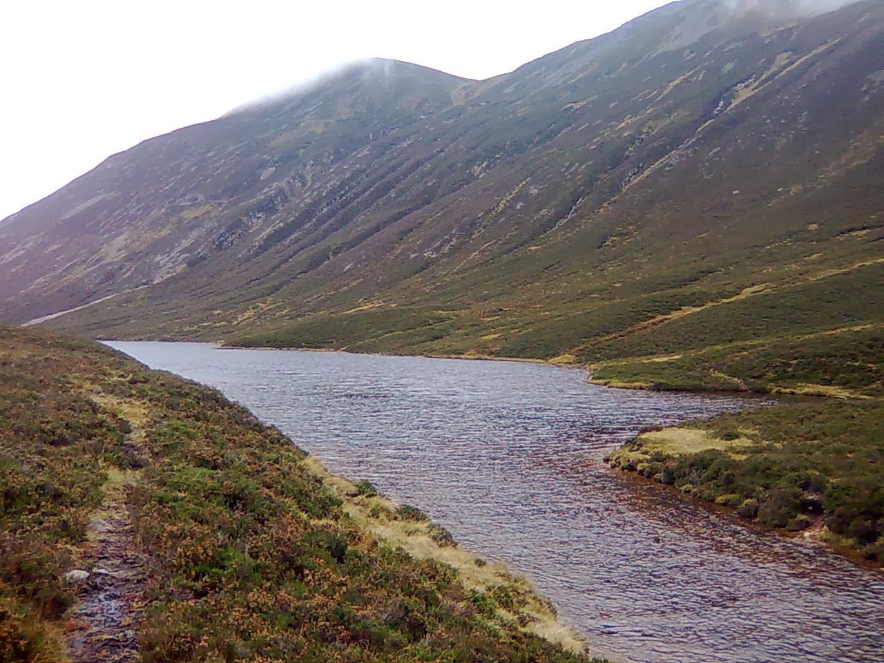 Every loch has an entry and an exit. Otherwise it wouldn't be a loch. It would be a nightmare. Filling with water, overflowing, flooding the entire world with brown, stinking mud. Here the place where this horror scenario is narrowly avoided. It looks quite unspectacular.
We could talk a lot about fording, but my basic rules are: Fording is great, unless you drown. Then it's not so great. in October 2013 the water slightly further down from the exit is only knee deep. In the background, K, dressed all black, wandering into an uncertain future.
The valve


Contrast this with the aforementioned image from October 2005, taken from almost exactly the same spot. The entire coastline around the valve seems to have exploded in winter 2005-6. What the hell happened here? We have a right to know.
October
This time: with K, and approach from the south. Straloch is absolutely nothing. But the valley has trees, trees with foliage and stems and everything. Apparently, planting different types of trees is some kind of pastime in the Straloch are. We also discovered a tarmac road which ends at the lodge a few miles north and passes only three or five miles from the loch. Quite a significant discovery. The future of the painless approach is here. And involves bicycles, probably.
October is different. The ferns are red. The midges are gone, hell, all insects are gone. The rivers are full with water. The loch is much colder. My feet hurt from the water. And through night and day the rutting stag make truly despicable noises. Despicable, yet surprisingly easy to imitate, especially after a bad cold.
We slept like thirty out of fourty hours at the lake. There was a lot of rain. In the remaining minutes, we managed to climb Gabhar and do some research. A weekend well spent, I would say.
Monday, July 15, 2013
Further research
The valve is changing. Compare the image in the post below from July 2013 with this image from April 2006 and with that image from August 2005. Especially the 2005 image, taken from the other end of the loch, indicates radical changes in the shape of the peninsulas. From memory, the valve was only slightly broader in August 2009 and images from 2011 show the same. Equilibrium my ass. What might happen here is a superposition of annual variations in the water level with a long-term evolution of the loch morphology due to ongoing sedimentation. One has to watch this.
Equilibrium
After two warm weeks, the loch was pleasant. But there is a catch. The spot where the stream flows into the lake, dividing the two halves of the beach, was brutally cold. The stream also produces an underwater mountain out of sand. I walked around the upper lake, wading through the "valve", the bit where two peninsulas almost touch each other from opposite sides. I wonder how much longer it takes until the sediments block the flow of water from upper to lower lake. And what would happen next. Will the water just rise again and overflow? Or will it find other ways? Is there an equilibrium? This spot just always seems almost dry. Maybe this is the equilibrium.

There are no rules here. It doesn't make any sense to go on with the old conventions, when nobody is around and no sign of human life can be seen. Everything is back on the table. Everything has to be renegotiated. With whom? Sheep, midges, grass. And whatever lives in the loch. I know nothing about the loch life.
Three hours, three hours to walk out on the proper trail to Loch Moraig. I wonder if there is a shorter way.
The difference
Went up to the ridge twice, the one that blocks the morning sun. Creag an Loch is it called in the OS map. The loch is called loch, the craig is called craig, this is the place where they ran out of names. From up here, the point at the tip of the peninsula looks like a soft, sandy swimming place. Need to try. I probably climbed the two highest points of that ridge, 710 and 701 meters, according to map. Once in complete fog, swirling stratus all over the place, once in the clear morning. What a difference.


Spent a lot of time watching swarms of midges and other insects, mostly while drying after yet another bath. Naked people have an unsatiable interest in the endeavours of insects, as it turns out. Not much learned, except confirmation that midges are indeed very sensitive. It might be more helpful to think of midges as lumps of matter that materialize out of nothing, instead of lumps of matter that move according to some unknown law. They always seem to appear in calm, humid, warm places, but nobody has ever seen them coming.
Sunday, July 14, 2013
The return
 I went back up there after basically 4 years. Not much has changed. The hut at the gate is now locked. Is it always? The trail up the first big mountain now looks like a nosebleed. Munroing killed that mountain. I missed the path that leads further north, made my own path which somehow never met the trail. A geometrical miracle. Anyway, reached the loch after four hours of bushwacking through heather and morast and horseflies. What a mess.
At arrival, the sun was out and it was dead quiet. These are the only conditions in which The Perfect Campsite is not really perfect, but this is of course extremely rare. I tried the first hillock on the peninsula. If the valley is some sort of lens for the wind, this is its focal point, the only point with a breeze even if it there is no wind at all everywhere else. A few hours later the wind came up and I decided to move the tent and everything to the Perfect Campsite at the beach. Several hundred meters along the loch with a tent on my back, fully erected, against the wind, are a mediocre idea. But, hey.
Subscribe to:
Posts (Atom)